


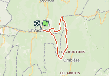
Le tour de la vacherie 12 .5.kms 876 m

Charignon
User

Length
12.4 km

Max alt
1421 m

Uphill gradient
876 m
Km-Effort
24 km

Min alt
847 m

Downhill gradient
876 m
Boucle
Yes
Creation date :
2024-04-11 06:56:03.672
Updated on :
2024-04-11 13:53:40.902
6h56
Difficulty : Very difficult

FREE GPS app for hiking
 SityTrail
IGN / Geographical institutes
SityTrail Plus
The world is yours!
About
Trail Walking of 12.4 km to be discovered at Auvergne-Rhône-Alpes, Drôme, Le Chaffal. This trail is proposed by Charignon.
Positioning
Country:
France
Region :
Auvergne-Rhône-Alpes
Department/Province :
Drôme
Municipality :
Le Chaffal
Location:
Unknown
Start:(Dec)
Start:(UTM)
672631 ; 4972721 (31T) N.
Comments